Grayton Beach Information
| Wetland Category: |
|
Flats & Beaches |
| NWI Classification: |
|
M2US2N |
| Latitude: |
30.321396 |
|
Longitude: |
-86.149592 |
Image Data |
| Date: |
|
12/31/1996 |
| Direction: |
West |
| State: |
Florida |
| Country: |
USA |
| Location: |
Grayton Beach |
| Author(s): |
Larry Handley |
| Affiliation: |
USGS, Mid-Continent Geographic Science Center |
|
| 
12/31/1996 | | |
|
|
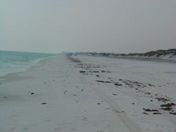
Description:
Marine Gulf of Mexico shoreline. Intertidal zone beach washed by daily tides. Regular daily astronomical tide washes to debris line along the beach.
|
Conditions: Normal daily tidal cycle below mean normal. Debris line and darker sand separate normal flooded daily tidal zone to the left from the irregularly tidally flooded zone to the right.
|
|
|
Disturbances: none |
|
Comments: |
